0 entities

0 fps

Log Every Core.
Miss Nothing.

The offline-first borehole logging platform for the teams who drill — geotechnical, environmental, mineral, water and construction. Capture intervals by hand or by voice, visualize stratigraphy in real time, and export client-ready logs — even where there's no signal.

3-day free trial · No credit card required · Works fully offline · Installs like an app

USCSCSSCMunsellSPTUTM / DLSGRYD Export
Explore
Who it's for

One platform,
both sides of the job.

The crew in the field and the team back at the office need different things from the same data. Drillr is built for both — and keeps them in sync.

Field Lead · Site Coordinator

Speed, simplicity & reliability

Built for the realities of the site.

Log soil, groundwater and well-construction details on an intuitive mobile interface. Full offline capability means you never lose data — even on remote remediation and reclamation sites with no signal.

  • Works fully offline — nothing lost when you're out of range
  • Large tap targets built for gloved hands and rough conditions
  • Standardized drop-downs stop typos before they start
  • Snap photos straight onto the interval you're logging
Project Manager · Environmental Analyst

Control, QA/QC & faster turnaround

Standardized data, straight to your desk.

Watch field progress in real time and cut hours of manual transcription. Drillr turns field inputs into consistent, review-ready borehole logs and monitoring-well records — formatted to the standard your deliverables demand.

  • Field-to-office sync as crews log, not days later
  • Automated logs & reports from the raw field data
  • One standardized vocabulary across every project
  • Historical site records kept in one searchable place
Voice Logging

Press record.
Talk. Drillr writes the log.

Describe the interval out loud in the field. Drillr records offline, then transcribes and extracts structured data — depths, USCS codes, colour, moisture, consistency, samples, observations — into a draft you review before it's saved.

  • Records fully offline — interpret when you're back online
  • AI extraction constrained to your real classification vocabulary
  • Per-field confidence flags — never silently writes data
  • Human-in-the-loop review before anything is committed
BH-04 · Voice capture
0:14
“New interval, zero to one point five metres, brown silty clay, moist, stiff, trace gravel, sampled at one metre, slight petroleum odour.”
Extracted Draft
depth
0.0 – 1.5 m98%
uscs
CL · Lean Clay95%
colour
Brown92%
moisture
Moist96%
odour
Petroleum (review)71%
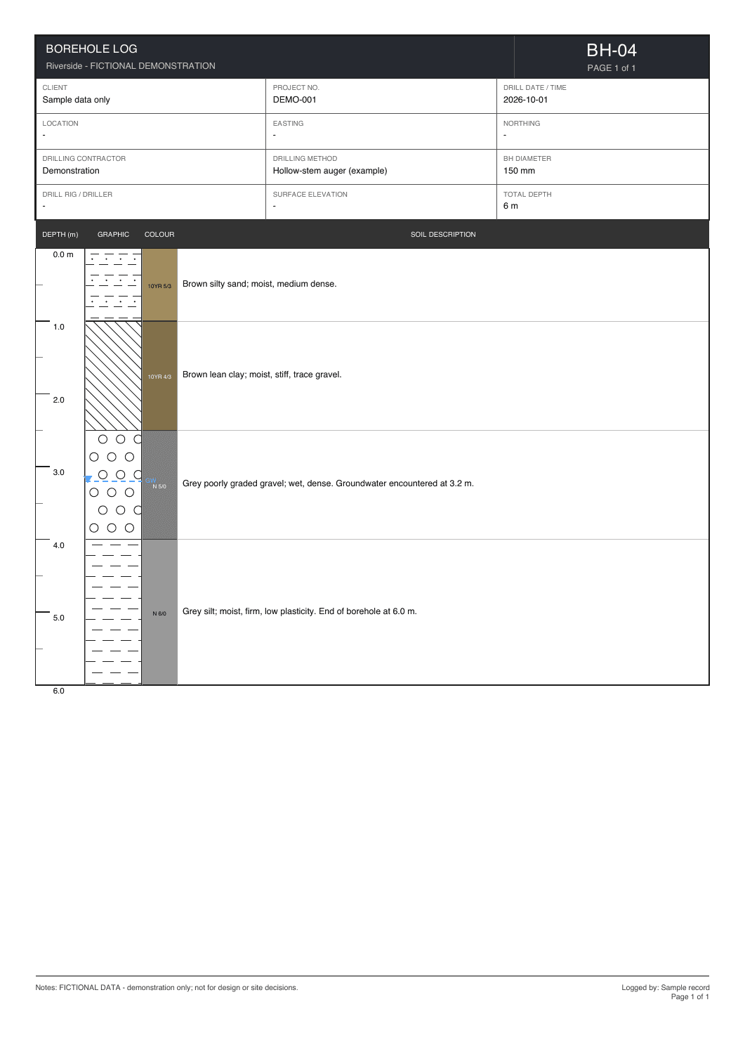
BH-04 · Stratigraphic log
DepthLithoColour & description
0.0–0.3
OL · TOPSOILDark brown, organic, roots
0.3–1.2
SMSilty sand, moist, medium dense
1.2–2.8
CLSandy clay, stiff, brown
2.8–4.5
GPPoorly graded gravel, dense
4.5–6.0
MLSilt, low plasticity, grey
Groundwater encountered at 3.2 m · sample @ 1.0 m
OrganicSandSiltClayGravel
Graphical Lithology Logs

Real stratigraphy, drawn to standard.

Drillr renders true USCS & CSSC lithology hatch patterns — gravel pebbles, sand stipple, silt dashes, clay hatch, organic waves — with a Munsell colour column, depth ruler, water table and sample markers. On screen as you log, and in the PDF report.

  • Standard USCS & CSSC pattern set, including dual symbols
  • Munsell colour swatch column beside every interval
  • Water table, sample markers & refusal depth annotated
  • One-tap, client-ready PDF aligned to industry log layout
Multi-Borehole Comparison

See the whole site at a glance.

Pull every borehole in a project into one view and read the subsurface across the site — correlate layers, spot the water table, and check continuity before you drill the next hole.

  • Side-by-side graphical logs at a shared depth scale
  • Correlate stratigraphy across the full investigation
Compare borehole logs · Riverside Site

BH-01

OL
SM
CL
ML

BH-02

OL
SM
CL
GP

BH-03

OL
SM
CL
GP

BH-04

OL
SM
CL
ML
0 mshared depth scale6 m
The workflow

From auger
to final report.

One continuous line from the crew's first interval to the deliverable on the client's desk — no paper hand-off in between.

01
The field

Capture

Log intervals by hand or by voice on a phone or tablet — soil, groundwater, samples and observations — fully offline.

02
The cloud

Sync

The moment signal returns, records upload automatically to one central project — no cables, no manual imports.

03
The office

Deliver

Managers open finished graphical logs and export client-ready PDF, GRYD, Excel or CSV — no re-typing.

Integrations & Interoperability

Fits into the stack
you already run.

Drillr isn't a walled garden. Your field data flows out in open, standard formats — and for enterprise teams, we build the connections your organization needs into the tools it already depends on.

Enterprise

Custom integrations, built to your requirements

On the Enterprise tier, our team builds bespoke integrations around your workflow — piping Drillr data into internal dashboards, corporate reporting tools, GIS platforms or CAD systems so field records land exactly where your business needs them.

  • Scoped to your systems and data model
  • Feed live field data into internal dashboards
  • Connect to your existing GIS / CAD / reporting stack
Talk to us about a custom integration →

GIS-ready exports

Every borehole carries GPS, UTM and DLS coordinates. Export to CSV or Excel and drop your data straight into a GIS project for mapping and spatial analysis.

CAD-compatible data

Structured interval and coordinate data formatted to feed environmental drafting and CAD workflows — no re-keying logs into your drawing set.

Your data, always yours

Export the complete dataset — intervals, classifications, chemistry, samples and readings — to GRYD, Excel or CSV whenever you need it. No lock-in.

Pricing

Simple, Transparent
Pricing

Start with a free trial. No credit card required. Scale to enterprise when your team is ready.

Individual

For solo operators & consultants

Most Popular
$103.20/month

Billed monthly · 12-month commitment

$129/moSave $25.80/mo (20% off)

3-day free trial · No credit card required

  • Unlimited projects & boreholes
  • Voice logging with AI extraction
  • Offline-first with automatic sync
  • Graphical lithology logs & PDF reports
  • GRYD, Excel & CSV data export
  • Custom forms, maps, photos & codes
  • 1 GB cloud storage
  • Email support
Start Free Trial

Enterprise

For teams & organizations

Custom

Sales-led onboarding · seat-based licensing

  • Everything in Individual
  • Company Admin Center & roster management
  • Per-project collaborators & viewer roles
  • Seat-based licensing & company-wide oversight
  • Database-enforced security (RLS)
  • SSO / SAML authentication
  • White-label branding & custom report templates
  • Custom integrations built to your requirements
  • Dedicated onboarding & priority support
Contact Us

All plans include SSL, GDPR compliance, and 99.9% uptime SLA.

Contact

Let's Talk Enterprise

Interested in white labeling, API access, or a custom deployment? We'd love to hear about your project.